Digitally Simplifying Closure in Complex Landscapes
A Spatial Ecology Case Study in Biodiverse Mountains
Nestled in a rugged, high altitude region, this site faced a complex restoration challenge. Unlike typical coal basins, this hydroelectric site was characterised by steep terrain, dense vegetation, and remote access further complicated by post-fire landscapes.
The team had a strong intuition regarding the site’s risks, including impacts from brumby, weed pressure, and burnt areas that had set back regrowth. However, they struggled with a reliable, scalable approach to gain a comprehensive view of the rehabilitation area with insights on ecological impacts. Seasonal isolated observations were not encompassing the complex landscape they are managing.
To achieve this, they partnered with Dendra to utilise spatial ecology on a variety of aerial data types. The objective was clear: create an in-depth understanding of the rehabilitation progress to support a data informed narrative for regulatory compliance.
Challenge: Good Assumptions, Incomplete data
With a rugged and fragmented site, some parts are only accessible on foot, while others can only be accessed by helicopter. Posing additional complexities of scale and accessibility for traditional field surveys, emphasising the necessity for advanced spatial intelligence to increase safety, reduce costs and increase ecological data capture.
Despite these challenges, demonstrating closure readiness is paramount at all stages of the project’s lifecycle. The team needed to showcase not only the progress made, but proof of what had been rehabilitated, what was struggling due to fire impacts and the processes undertaken for recovery. Their initial understanding of flora and fauna dynamics was limited, and they lacked the data to justify what was or wasn’t feasible under their current completion criteria. Guesswork was insufcient; they required evidence.
The Shift: A Whole-of-Site View That Connects the Dots
Dendra deployed high-resolution colour and multispectral sensors across the entire rehabilitation area, including areas that had never been surveyed before due to access constraints. This resulted in a highly detailed, repeatable map illustrating flora and fauna dynamics, changes over time, and alignment with the site’s completion criteria.
For the first time, the team had a mapped-out view of target species on site, weed distribution, brumby activity zones, and patterns of regrowth in areas affected by fire. This data empowered them to move beyond fragmented assessments, enabling a more thorough narrative that conveyed both achievements and realistic future paths.
There’s a strong case for integrating the Dendra Platform and imagery workflows into the site’s rehabilitation strategy. This is not just about detecting Gamba, it’s about shifting the entire compliance framework into a more robust, digital first, data-driven approach. This is more than a point solution for Gamba.
The Dendra Platform enables:
• Species detection across native and invasive flora
• Vegetation health monitoring using multispectral (MSP) and RGB together
• Erosion and slope risk analysis • Landform change modelling
• Feral animal tracking
• Spatial, spectral and temporal change tracking
Future Digital Compliance
Had Dendra’s approach been adopted earlier in the mine’s lifecycle, the Gamba outbreak could have been managed more proactively, with fewer blind spots, and lower costs. This isn’t about missed chances; It’s about seizing a turning point.
Digital assurance through colour and multispectral imagery offers verifiable, regulator-ready insights. It’s not just about presence/absence mapping but layered intelligence that tracks time-series trends, spatial context, and species-tagged output, all auditable and designed for regulatory scrutiny. This transparency transforms complexity into a clear, actionable roadmap.
By capturing colour and MSP imagery simultaneously, the combined datasets power multiple outputs, enabling adaptive, year-on-year progress tracking. Instead of static field calendars, sites can respond to what’s happening on the ground now, whether it’s an identified Gamba resurgence, or feral fauna getting too comfortable. Rehabilitation becomes measurable in movement, not just milestones.
Most importantly, the investment compounds. Every Dendra flyover becomes a reusable asset, informing rehabilitation, shaping future approvals, and building trust. This is how sites can reduce compliance costs, accelerate approvals, and sustain long-term regulatory confidence not through guesswork, but through a smarter, digital-first compliance strategy.
Resolution: A Smarter Path to Relinquishment
Achieving total eradication of Gamba may be an unrealistic expectation, and regulators might accept this. However, what they cannot accept is the uncertainty, inaction, or insufficient evidence. Now is the time to shift from merely managing a risk to owning a strategy.
By integrating site-wide ultra-high-resolution mapping into the closure strategy, the site can:
• Set new standards in environmental accountability
• Back every report with layered, auditable proof
• Reduce ambiguity in regulator dialogue • Increase chances of negotiated, data-justified thresholds
• Accelerate mine relinquishment by years, not months
In doing so, the site won’t just control Gamba, it will redefine what digital compliance will look like in modern mining.
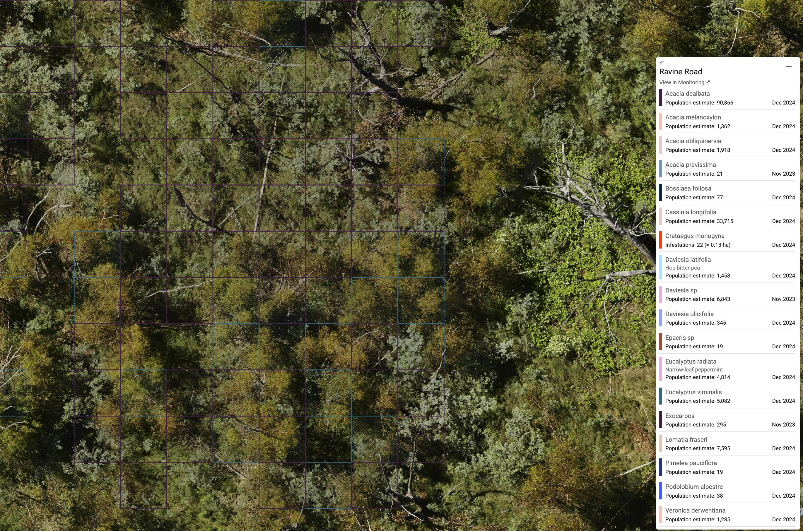
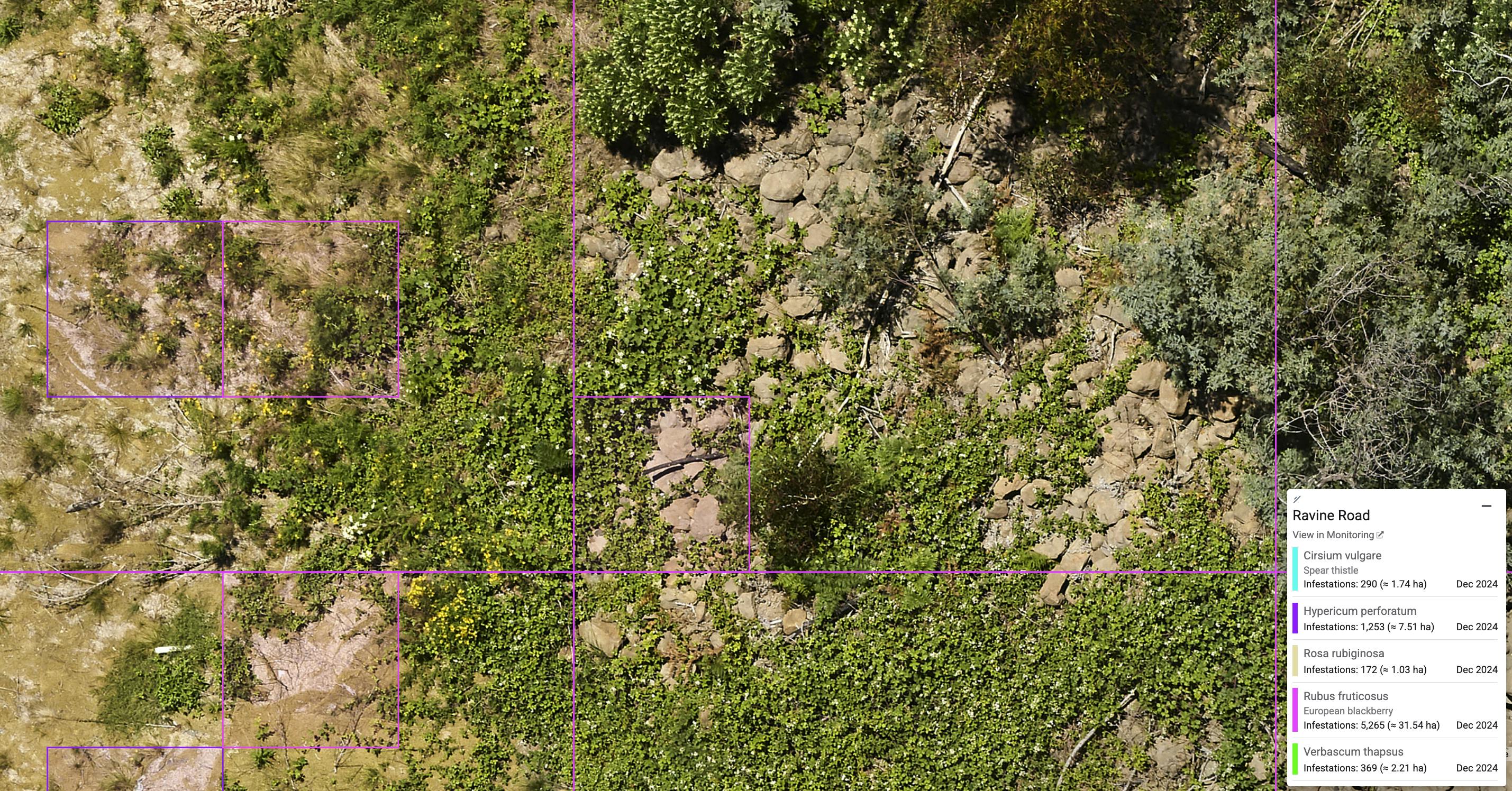
Figure 1. Detected native flora across hilly vegetated area
Lessons & Leverage
Had these digital tools been available earlier, much of the site’s progress could have been monitored over time. Weeds could have been flagged before they spread. Brumby paths could have been monitored, and fire recovery patterns could have been measured to a broader context, not just compared to pre-set targets. But what matters now is how the data is used from this point forward.
With Dendra Systems in place, the site now has a baseline for analysis, providing clarity on feasible outcomes and allowing closure strategies to be informed by the actual state of the land rather than assumptions.
Future Digital Compliance: Where Strategy Meets Assurance
The site’s experience underscores the critical role of digital ecology in supporting the management of complex landscapes. The core need was for a credible mechanism to demonstrate that the site was progressing towards an ecologically resilient future. One that would remain self-sustaining, stable, and non-polluting long after the handover.
Dendra’s Optical Intelligence facilitated this by providing a unified dataset, incorporating species detection, vegetation structure, landform modelling, and erosion risk assessment - all captured in a single flight and timely format suitable for regulators. This digital play transforms static reporting into a living system of assurance. The team can now continuously measure, track and update site conditions, not just during obligatory audits.
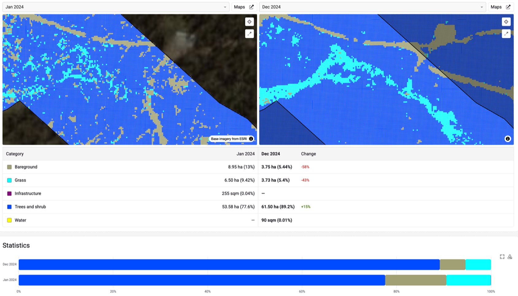
Figure 2. Land cover classification comparison over 2 time periods
This adaptive approach enables early identification of data gaps early, reduces risk to closure certification and supports evidence-based decisions. Each aerial survey contributes vital insights, adding confidence, reducing uncertainties, and making closure criteria attainable.
Resolution: A Clearer Path to Closure
The site achieved more than just a survey; it developed a strategic framework for effective rehabilitation. With Dendra, they now possess the tools to:
• Communicate clearly with by using data backed insights.
• Monitor progress over time, not just at compliance checkpoints.
• Proactively i risks that could impede closure.
• Foster confidence in the long-term sustainability of the land
By transitioning to a digital-first monitoring approach, the team illustrates how modern compliance can be achieved even in the most challenging terrain.